The new housing by the side of the A34 in Churchbridge has an interesting past if you have any interest in canal or industrial history. The site which was behind the Robin Hood pub in Churchbridge was formerly Gilpin’s Works, an edge tool manufactory established by William Gilpin (c.1775-1835) c.1799. Grace’s Guide has a short page about them.
Some history on the Robin Hood and its close connections to William Gilpin can be found here on Wyrley Blog.
Most of the site’s buildings were erected in 1806; edge tools were certainly being manufactured there by 1817. From an old tool enthusiast’s site
“These locations and operations are also described in some general commentary about the area in the same 1834 Directory. I think it worth repeating here, as it reminds us of the importance of water power for the siting of such works, gives a fuller idea of the enterprise, and provides a rough idea as to when the firm may have been established:
“Church Bridge is a small village in Great Wyrley township, 1 mile S. of Cannock, on the Watling street, and on one of the tributary streams of the Penk, where Mr. Gilpin established, about 35 years ago, an extensive manufactory of edge tools, augers, hammers, &c., and a forge, a tilt, rolling and grind-mills, and furnaces for converting and refining iron and steel; all of which are now in a flourishing
state, and give employment to a considerable number of workmen. About one mile to the west is Wedges Mill, a hamlet in Cannock township, where Mr. Gilpin has another edge tool manufactory on the Hedgford rivulet.”
This description would place the establishment of the Church Bridge works at about 1800. I would surmise that the Wedges Mill site had less water power than the Church Bridge site, which raises the
question as to why George Gilpin would have had two separate works in such close proximity? Possibly he had purchased the Wedges Mill site from a smaller, competing, firm?
In any event, George Gilpin is also listed, in 1835, as an edge tool, and bar iron and steel manufacturer at Wedges Mills and at Churchbridge.
Ownership of the firm has changed by the 1842 listing:
William Gilpin & Co., Wedges Mills & Church Bridge, edge tool and bar iron and steel manufacturer (and brewer) [William Gilpin & Co., coal masters, Great Wyrley & Pelsall]
By 1851, the listing reads:
William Gilpin & Co., steel converters, tilters, rollers, edge-tool mfrs., coal masters and brick makers, Church Bridge & Wedges Mills.
Bernard Gilpin (of William Gilpin & Co.), edge tool &c. mfr.
I’ve also been able to find listings from 1870 (William Gilpin & Co.), 1904 and 1912 (William Gilpin, Sen. & Co. Limited) – the latter two providing a fairly extensive list of their products as well as
information that they had become “Contractors to His Majesty’s Government.” The 1904 Directory, in a general description of the area around Cannock, indicates that the firm was employing “hundreds of
workmen” at that time.
An 1876 “WM. GILPIN, SENr. & CO.” advertisement gives a fairly clear idea of the diversity of their products:
Patent Screw Augers and Boring Bits
Heavy & Light Edge Tools, for the following purposes:-
Agricultural & Garden | Coopers
Bricklayers | Masons & Plasterers
Carpenters & Joiners | Quarrying & Miners
Contractors, Platelayers, | Ship Carpenters
&c. | Smiths & Farriers
Plantation Tools,
Matchets or Cutlasses, Cane Bills, &c.
For all Colonial and Foreign Markets
Anvils, Vices, Lifting Jacks
Cider Press and other Screws, Chains, &c.
Bar, Hoop, and Use Iron
Cart Arms, Axle Moulds, &c.
Steel of Every Description
In its later years, from c.1980, the site was part of the larger Britool group, which had its origins in Wolverhampton in 1915. After closure the site was purchased by a developer and housing has since covered the whole site.
Original development of the site was fostered by two canals. The Wyrley Bank Branch of the Wyrley & Essington Canal lay to the south approved by Parliament in 1792 and a section opened to Essington in 1798, only to close in 1829. However, the canal was reopened in 1857, this time all the way through to Wyrley Wharf on Dunduck lane (now Dundalk lane) where it was surrounded by mine shafts and also Brick and tile works, 3.5 miles north of Sneyd.
Gilpins basin on the Wyrley Bank branch, located near to Upper Landywood and the new cemetery, had a mineral railway associated with it, the mineral railway ran from the basin to Great Wyrley Colliery and from there up to the tool works adjacent to the A34.
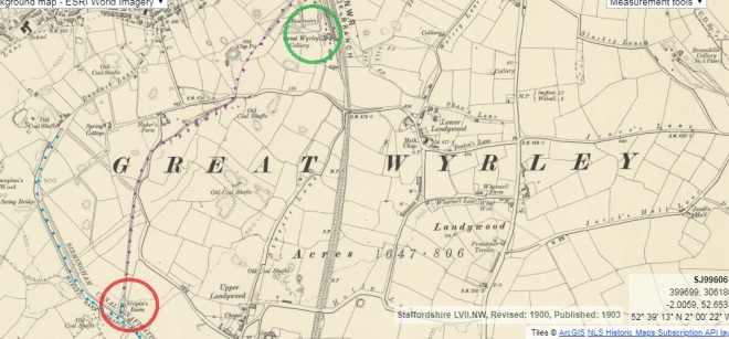
Here on Map 1 you can see the Basin circled in red with the tramway dotted in purple where it runs up to Gt Wyrley Colliery circled in green.
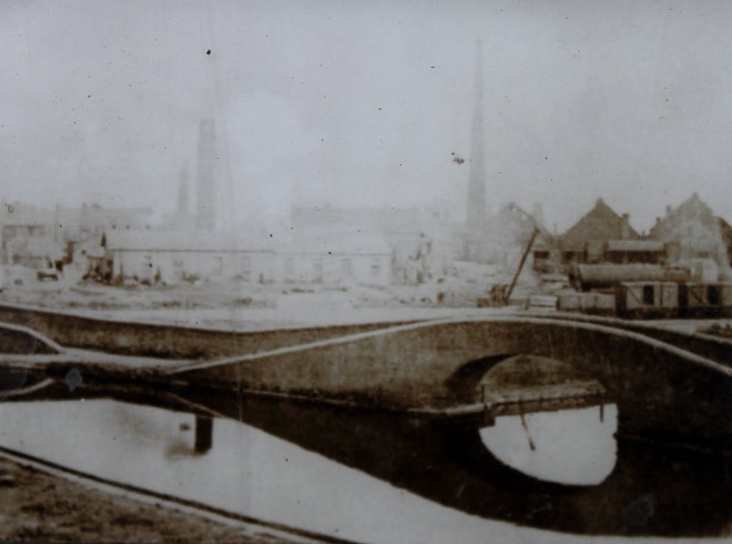
To the north ran the Hatherton Branch of the Staffordshire & Worcestershire Canal which was constructed c.1860 and was fed by the contemporary Hatherton Reservoir. A rail/canal transhipment basin and shed was also built in 1860 jointly by South Staffordshire Railway Co and Staffordshire & Worcestershire Canal Co. Just to confuse matters this also became known as Gilpins basin, built at the foot of Churchbridge locks and adjacent to the works site, the above image of this basin was found on Capt Ahabs site.
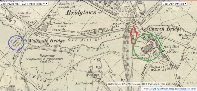
Here on Map 2 you can see this basin outlined in red and its location within the edge tool works with rails alongside for transhipment. The works (circled in green) also had a tramway, which is clearly marked on the map) running to it from Great Wyrley colliery and this tramway linked to the original Gilpins basin on the Wyrley bank branch.
The Hatherton canal closed 1963 due to subsidence and loss of water, but the reservoir, although reduced in size, is retained as a local nature reserve. The outline of the canal basin, railway sidings and a crane base were described as being extant by Ian Langford in 1974.
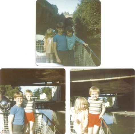
Evidence of the subsidence can be seen in these photos taken c. 1950 showing the building up of the canal banks with new brickwork, seen under the gentleman standing alongside the boats on the left of the image and the way the surrounding landscape is much lower than the canal, eventually most of this area was obliterated by a large open cast mine which consumed almost the whole of the Churchbridge lock flight.
 1955.")

Gilpin’s firm may have been the first edge tool manufacturers to install water-powered hammers in the Staffordshire area, if not in England. The site was therefore not without historical or archaeological interest.
Archaeological investigations in advance of the M6 toll road and housing revealed the remains of both a canal basin with associated railway interchange and the early to mid 19th century edge tool works (comprising brick walls, yard areas and forging hearth flues). Railway tracks were revealed leading from the canal basin to the edge tool works.
Map 3 here shows the original/final (maybe) piece in the Gilpin/canal story, the Gilpin Arm itself. The red circle shows the location of the small bridge shown in the photo on Capt. Ahabs blog Here
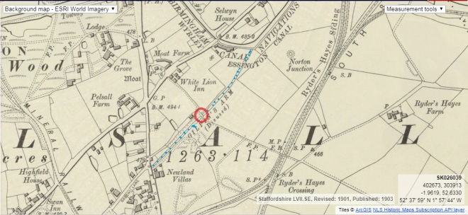
The Gilpin arm was an extension arm to the W&E canal, built by William Gilpin, c 1800 to ship coal, iron and limestone from his mines on the Ryders Hayes/Newland fields, tramways led to the mines. The authorising act dates to 1794 the same time as the main Wyrley and Essington act. The Gilpin family rented the land from ‘Squire’ Charles, of Pelsall Hall, in to the 1860s. The canal, however, was largely derelict by the 1840s and abandoned ten years later, at which time it was known as The Old Arm, a place for wild birds and family outings. Most of it was filled in and developed as a housing estate in the 1970s. The arm itself ended adjacent to Newland Villas near the junction of Norton Rd/Green lane and extends back under Ryders Hayes School to the canal, where if you look carefully, you can just make out a change in the brickwork on the bank where the arm used to leave the main line.
Sources : BlackCountryHistory.org
Captain Ahabs watery tales
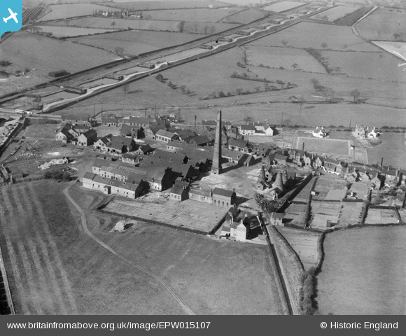
https://britainfromabove.org.uk/en/image/EPW015107
Map 1 georef – http://maps.nls.uk/geo/explore/#zoom=15&lat=52.6557&lon=-2.0298&layers=6&b=1
Map 2 georef – http://maps.nls.uk/geo/explore/#zoom=16&lat=52.6718&lon=-2.0316&layers=6&b=1
Map 3 georef –
http://maps.nls.uk/geo/explore/#zoom=16&lat=52.6357&lon=-1.9677&layers=6&b=1