Walsall royalty

QUEEN was launched in 1917 and constructed by an unknown builder. The first owners of this narrow boat were Hildick & Hildick of Walsall and she was originally named WALSALL QUEEN.

queen
Walsall Queen after sale to A. Harvey Taylor and renaming to Queen, this image shows her just after some serious dock work and the rams head has been removed.

BCN Distance tables show Hildicks works, the tube works that is, as on the Walsall Canal, near Pleck, through discussion with Nick Hildick-Smith a descendant of the Hildicks I received this potted history of the firm

Moore Hildick became a file and iron square manufacturer, like his father, and conducted business in Wolverhampton Road, Walsall (Whites Trade Directory of Warwickshire 1834).

However, Mona Hildick-Smiths’ letter says:

“ My Great Grandfather (Moore) Hildick had a large flour mill and he wanted my Grandfather John to take it over- but the flour upset my grandfathers chest so an iron and steel tube works was started for him”

Moore married Sarah Wood on 9/8/1821 at St Matthew’s, Walsall . They lived in Walsall, in Wolverhampton Road, and had 6 (or 7) children.

Benjamin b1822 c 8/5/1822

Joseph Moore b1823 c 15/10/1823

John b1825 c 31/3/1825

Sarah b1826 c 1/1/1827

Moore* b1828 c 4/6/1828

Elizabeth b1830 c 24/3/1830

Martha b1841 (This not proven but comes from a source through Genesreunited.)

All the children were christened at St Matthew’s Church, Walsall. The two eldest boys obviously inherited the file manufacturers as John became a grocer. This is at odds with the information in Monas letter who says he was in the iron and steel tube business.

The following has again been found recently and refers to the iron businesses in Walsall in the 19C:

“Several other works were set up in the mid 19th century. In 1855 Edward Russell opened the large Alma Tube Works on land leased from Lord Bradford at the corner of Rollingmill and Wharf Streets. (Footnote 65) By 1860 it had passed to John Russell & Co. of Wednesbury. (Footnote 66) The company continued to occupy the works until 1929 when Stewarts & Lloyds took over Russells and closed it. (Footnote 67) In 1860 another firm, Brown & Chesterton, was making tubes in Station Street, but by 1873 it was concentrating on gasfittings and chandeliers. (Footnote 68) Three more works opened in the 1870s. (Footnote 69) George Gill, manager of the Alma works in 1872, and a Mr. Hildick had by 1876 established the Walsall Tube Works on the north side of the Cyclops Ironworks in Pleck Road. (Footnote 70) Gill left the partnership c. 1879 and the firm became Hildick, Mills & Hildick. (Footnote 71) The style changed to Hildick & Hildick in 1884. (Footnote 72) About 1876 A. C. and J. G. Russell, trading as Russell Bros., opened the Bradford Tube Works in Upper Brook Street. (Footnote 73) The firm became Russell Bros. (Walsall) Ltd. at some time between 1917 and 1920. (Footnote 74) About 1880 George Gill had joined with T. A. Russell to establish the Cyclops Tube Works on that part of the Cyclops Ironworks site flanking Wharf Street. (Footnote 75) The firm became Gill & Russell Ltd. in 1911. (Footnote 76)”


From: ‘Walsall: Economic history’, A History of the County of Staffordshire: Volume XVII: Offlow hundred (part) (1976), pp. 180-208. URL: http://www.british-history.ac.uk/report.asp?compid=36193. Date accessed: 01 June 2005. Notes relate to source documents, mostly meeting minutes and can be seen at the web site.

It should be noted that I have found references to Hildick and Hildick trading in the Birmingham area up to the mid 1940’s and a recent contact with Greta Morley (nee Hildick) whose father Howard, a son of John Hildick (1857), ran the company until its demise in the 1950s, has clarified some details.

I think therefore the Tube Works came into being in around 1876 but became Hildick and Hildick in 1884. As far as I can tell from a short conversation with Greta (who died recently (2013)) the two Hildicks concerned were Benjamin and Joseph shown in the tree extract above. I descend from John the third brother who was mostly a farmer at Lapworth but who did serve as Mayor of Walsall in the late 1800’s. I am sure that the two brothers died without issue and all the works passed to Johns son also called John. When this John died in around 1912, his son Howard (Gretas father) took over the company and it ran in various guises until the mid 1950’s. The only snippet re the boats was that the company was having great difficulty in getting sufficient canal carriers to transport their pipes that they decided to make a small fleet of their own. It appears that very few were made as they only created them for company business reasons and presumably with the onset of rail and road transport were sold off when no longer required.

It was around 1917 that Hildicks had their boats built and maybe the war was a consideration, at that time it was stalemate on the western front and war production must have been taking over everything, Hildicks were iron and steel tube manufacturers so I imagine they would have had quite a bit of production aimed towards the war effort.

A 1916 advert for Hildick and Hildick from Graces Guide

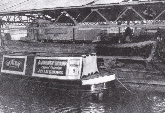
Walsall Queen was paired with a butty boat called Sybil and both were sold to A. Harvey Taylors in 1924, they also had Colin and Iris of AHT but they came via Nicholsons a firm in the London area. According to Chris Leah of Wooden Canal Boat Society Hildicks also had a butty called “Queen of the Ocean” , which together with their motor “Whitehall” was sold to John Boyes of Hillmorton in about 1923. “Queen of the Ocean” was later traded in for the “Victoria” at Tooleys and on John Boyes death in 1935 were sold to Harvey Taylor, becoming the “Leon” and “Rose”

Walsall Queen was constructed of wood; transverse elm bottom, iron knees and carvel sides. She was purchased by A. Harvey-Taylor in 1924 and re-registered as QUEEN at Tring. Her original engine was replaced at this time with a Bolinder semi diesel. She was abandoned in 1947, then sold as a pleasure boat in 1949. Abandoned again in 1986, she was rescued as a houseboat. In 1993, she sank and was left at Denham. The following year, British Waterways donated the boat to the Wooden Canal Craft Trust (now the Wooden Canal Boat Society Limited) who raised her and moved her 200 miles to Runcorn for preservation.

queen1
Walsall Queen having been wrongly identified as Fellows Morton and Claytons Queen, rescued by WCBS she is here on her journey from Denham on the Grand Union to Portland Basin nr Manchester.

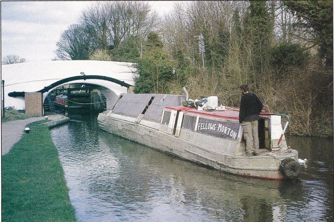
She rests now at The Portland Basin Museum, Ashton-under-Lyne where she is the last survivor of the Hildick & Hildick fleet with a hull unaltered from its original construction.

WCBS are raising funds towards the restoration/rebuilding of Walsall Queen, hopefully this centenarian lady could one day grace the canals of Walsall once again, how great would that be.

When is a culvert not a culvert?..

When its a ruddy great hole in the ground of course, top bloke and local boater Springy has sent me some images of the works at Teeces Bridge, Little Bloxwich and works is the right word for them. The culvert is now a trench from one side of the cut to the other with just the ends remaining, as you can see on his photos the culvert was of double layer brick construction built completely round and probably hasn’t seen light of day since being built 224 years ago or something close to it. The stone seen in my previous blog post Surveying the kingdom has been used to create a ramp/roadway for the tracked excavator that’s on site and creating the hole.

There are now 5 pumps running according to Springy 3 transferring water from Pelsall side to the Walsall side and two which are keeping the work site as water free as possible, as you can see from the images the flow from Chasewater is bringing the surface muck on the canal down to the dam.


With the works planned to be completed by July 6th they are cracking on which is lovely to see and after discovering the leak we can have few complaints about the progress made so far. I love the detail Springy managed to get of the brick culvert before it is replaced, I think the guys have probably been too busy to keep a photographic record themselves which is a shame as it would have been interesting to see exactly what the damage was before it was cleared away.

I feel an enquiry to Severn Trent coming on…

Hindsight eh

I was going to write today how with hindsight I may have been a bit unreasonable towards CRT yesterday, it wasnt so much confusion as the confusing manner of the stoppage notices which got me goat. Id spent the day reading about the various stoppages round the system and was in a bad mood with much ire aimed at senior managers within CRT. I probably was harsh on them and I apologise, today Ive been told the Church Bridge stoppage is now off again and will happen as originally planned in November. This decision was made because having both stoppages at the same time would mean a large section of canal was closed and a big diversion in place. Its really pleasing to see such common sense being utilised about this.

Im not going to moan about this because it was what I mentioned yesterday and it does now mean the W&E is back available as a through route if boaters are willing to travel along the Walsall cut. Personally I think its a great bit of canal, like all urban canals it has its problems with rubbish and ASB but they are not as serious as we might think, if it happens to you its awful and off putting but its nothing new. Indeed 30 odd years ago it wasnt unknown for boaters to carry their own half enders and whatever to lob back at the kids if they offered the same towards the boats, Ive been dropped off at a few points as a youth and told to chase off some of the offenders, not something Id recommend to be honest.

99 times out of a hundred there is no trouble at all travelling these canals, a friendly smile and wave goes a long way, and they offer some of the best views of industrial archaeology and the changing faces of city/brownfield sites you will see. Yes there are stretches where the locals have little regard for the canal but it also has sections that are simply beautiful and planners and developers have made great improvements and really brought the canalside back into use. Brownhills Bob is a huge advocate of canals as a leisure resource, he comes at it from a cycling position as opposed to my boating one but thats the beauty of canals, there is room for us all as long as we are prepared to be considerate and thoughtful. Ive cycled, walked fished and boated most of the BCN at various times and it amuses me how sometimes we each see “our” group as somehow superior and having the priority when it comes to canals. As a boater I have to remember its 2018 not 1918, commercial carrying is finished, canals are now leisure based which means we can all use them on level footing, as long as there’s water in them of course.

CRTs latest drive “Making life better by water” is a positive one I think, it will raise awareness of canals as a leisure resource for cyclists and walkers and hopefully will bring a bit more respect to the canals and boaters from those who at the moment just see them as somewhere for mischief, as evidenced at Ryders Green locks this morning

As a result of this childish moronic behaviour Ryders Green Locks are closed overnight (4pm-8am) as per this notice.

The damage caused is superficial it seems but it reduces the attractiveness of the whole area.

https://twitter.com/BashirMbe/status/1007242970179997696

I can only think that CRT staff are in attendance during the day to ensure safe passage, otherwise I would have thought the anti idiot keys on the paddles would be enough… although somehow the idiots must have bypassed them last night it seems.

Lets hope CRTs message of hope about canals can penetrate those responsible and they find a new way to enjoy the waterside, one that doesn’t cause problems for others.

Get out there and enjoy the towpaths, get a fishing rod and licence and enjoy the wildlife, better still get away on a boat and truly experience a different way of life and see what people like me rave about.

Its well worth it.

Confusion reigns at CRT

I have no intention of making this blog another attack CRT blog, theres enough of those out there, however their latest notice regarding Teeces Bridge/Little Bloxwich W&E closure is full of conflicting information.

Teeces Bridge (Stoney Lane Little Bloxwich) Wyrley & Essington Canal

Notice Details

From Date:
2nd June 2018 at 13:00
To Date:
6th July 2018 at 18:00 inclusive
Type:
Navigation Closure
Reason:
Structure failure
Notice updates:
13/06/2018 @ 15:17

Following the emergency closure at Teeces Bridge, we expect the repair works here to be completed by 6th July.

We have also contacted the Third Party contractors, Bagnalls (for Cadent Gas) to see if we could work together to bring forward their planned November winter works at Church Bridge, Wednesfield to coincide with this unexpected closure of the navigation.  As a result, we are pleased to confirm this closure will now be carried out from 18th June – 6th July.  This will avoid having a further stoppage on the navigation in the winter.  A separate notice will be issued for these works.

07/06/2018 @ 16:21

Further to the below notice, Severn Trent have accepted ownership of the culvert and are undertaking repair works.

Whilst the towpath remains open, banksman will manage users through the works as and when necessary.

Description:

A culvert that runs below the canal has collapsed and the level of the canal is continuing to drop so we need to isolate the section with the leak to protect the remainder of the canal.


Please note the Northern and Southern Sections of the canal are all open and can be accessed via the Tame Valley and Rushall Canals or either the Walsall canal or Wolverhampton Main line.


Location:

Wyrley & Essington Canal
Starts At:
Teeces Bridge
Ends At:
Teeces Bridge
Up Stream Winding Hole:
North of Teeces Bridge use the junction with the Cannock Extension Canal
Down Stream Winding Hole:
South of Teeces Bridge use Birchills Junction

While it is great news they plan for the waterway to be back open by 6th July, in time for school holidays, their information about Church Bridge in Wednesfield would seem to indicate the canal is no longer opened from the main line through to Walsall.

If the works at Wednesfield necessitate a closure as they seem to suggest they need to change the information about the W&E being open from the main line immediately as any boat getting that far would have quite a way to reverse to wind when they come across the stoppage.

The stoppage notice has been issued and the W&E is indeed closed at Church Bridge.

Church Bridge, Wednesfield, Wyrley & Essington

Notice Details

From Date:
18th June 2018 at 08:00
To Date:
6th July 2018 at 16:00 inclusive
Type:
Navigation Closure
Reason:
3rd Party Works
Is Towpath Closed?
Yes
Description:

Third Party contractors, Bagnalls, will be carrying out works to this pipe bridge on behalf of Cadent Gas.  This will require the installation of scaffolding which will necessitate closure of the navigation.

Following the emergency closure on the Wyrley & Essington Canal at Teeces Bridge, we contacted Bagnalls to see if we could work together to bring forward their November winter works at Church Bridge, Wednesfield.  As a result, we are pleased to confirm this closure will now be carried out during 18th June to 6th July.  This will avoid having a further closure on the navigation this winter.

Location:

Wyrley & Essington Canal
Starts At:
Trapmakers Bridge
Ends At:
Rookery Bridge
Up Stream Winding Hole:
Bridge at Basin Junction
Down Stream Winding Hole:
Wednesfield Junction Turnover Bridge


A boater would know this and realise the glaring error, be interesting to know is the person writing these notices has much experience on boats and canals or just reading a map even, its not good either way.

In retrospect and reading them carefully what they say is technically correct, I feel it needs clarification from them however to ensure people who dont know the area have a full understanding. While technically the canals are open other than the two very short lengths described, there is no through route on the W&E from Wolverhampton or Walsall or Pelsall, you CAN use the Daw End canal and head down Rushall locks from Pelsall side, you CAN use the Walsall canal to get as far as Birchills really and you can access Bentley Bridge from Wolverhampton side but you cannot do all of those together at this point.


Hope that is a bit clearer.

Once more unto the breach…

Reports are coming in about another canal breach, this time on the Leeds and Liverpool canal nr Maghull just outside Liverpool, contractors are dumping rubble and soil in narrows to try and slow the flow but its all being washed away so far. Boats are grounded and a huge amount of water is flooding local fields according to photos on facebook. https://www.facebook.com/groups/1407105596036513/permalink/1722259847854418/

Its unclear if this is near the site of the 1994 breach detailed below but sadly as explained in the text below with their being no locks between Stanley Dock and Burscough  Appley Bridge (being the next lock with Birscough being a lock down onto the Rufford branch, Thanks to Michael in the comments below) a huge amount of water is being released from the canal.

“The reason so much water escaped is that there are no locks between Stanley Dock in Liverpool and Burscough in West Lancashire, many miles away. In effect all the water between Liverpool and Burscough was trying to leave the canal via the breach which was roughly half way between the two.

I recall watching what was then British Waterways (now the Canal & River Trust) desperately trying to stop the flow by dumping rubble into the canal at Bells Lane and it being washed away by the force of the water.”

https://tonyrobertson.mycouncillor.org.uk/tag/maghull-canal-breach/

I understand that the breach occurred after 6.30 this evening as eye witnesses say that all was fine as they walked along the stretch at that time, the only disturbance some kids swimming in the canal, seems like they had a lucky break.

As photos in the local facebook group show the water loss is serious and CRT are struggling to get a hold on the loss,  it doesn’t seem as if Stop planks are kept close to the stop places and as can be seen tipper trucks are dropping tons of rubble to try and save some of the water. Latest reports say sand bags are being dropped in.

CRT are reporting that a culvert has failed that heads over the field towards Brewery Lane (I wonder if from the Alt) The water from the canal is escaping down the culvert, flooding the fields and Brewery Lane. They have dammed one side trying to sort the Liverpool side pouring clay in to dam it. Someone is coming out to rescue the fish and wildlife.

Culvert 29 (Nr. Burscough) – Leeds & Liverpool Canal

Notice Details

From Date:
13th June 2018
To Date:
until further notice
Type:
Navigation Closure
Reason:
Structure failure
Notice updates:
13/06/2018 @ 09:36

The Leeds & Liverpool Canal is currently closed to navigation between Bridges 9C (Ledson’s Bridge) in Bridge 10 (Holmes Swing Bridge) due to a suspected collapsed culvert (No. 29) near Melling / Burscough.

Engineers are on site completing investigations and an update will be issued later today.

Description:

The Leeds & Liverpool Canal is currently closed to navigation at Bridge 10 (Holmes Swing Bridge) due to a collapsed culvert (No. 29) near Burscough.

An update will be issued later today.

Location:

Leeds & Liverpool Canal
Starts At:
Bridge 9C, Ledson’s Bridge, Melling
Ends At:
Bridge 10, Holmes Swing Bridge


As you can see from the following photos kindly provided by local, Les Nolan, the flooding is extensive and includes local houses with at least one boat caught in the damaged section and left high and dry.


Brewery Lane has now been closed due to the flooding.

It seems as if there has been a problem for a while in this area, locals reported a very strong smell in the last week coming from the area of the culvert and there is a quote from local farm owner in the Liverpool Echo

The 58-year-old told the ECHO: “We’ve reported a fault with the canal and a persistent damp patch, even in dry weather, for some time now.

“We have reported it consistently and not been believed.”


A fish rescue is taking place at lunchtime on  13.6.2018.

Images sent in by local Traci Googel, show the Liverpool side down about 2ft. Traci took these pics while walking her grandson to school along the stretch of canal between Cooksons bridge and the blue bridge by Hatton hill Litherland, which is approx 4km from the breach site by canal.

This whole episode does not seem to paint the area CRT management in a great light, reported leak which has failed despite numerous warnings, maybe and this is a wild thought, but maybe it would be best to have managers and a workforce who know what they are doing. Maybe the time is right for a refocusing on the core business and away from outside investments because without water, a canal is a stinking muddy ditch that NO ONE will feel better by.

Update 13.6.2018

The coffer dams are going in the usual scaffold and WPM jobs which should allow the sections either side of the breach to be rewatered.

Surveying the kingdom

Or the hole in the cut, roving reporters inform me that the surveyors have been in to the breach site over the weekend to assess the damage and locate the site of the breach exactly, according to my on the spot witness the actual breach is alongside the piece of barrier seen in the images below.

As a consequence of the Chasewater feed being turned off due to damaged paddle gear CRT brought in a hydraulic pump, the 6″ pipe obviously wasn’t cutting the mustard so an extra line was brought in this time an 8″ one to really shift some water. They’ve certainly done that with the level on the Eastern/Northern side of the breach being within 30mm of the head of the dam wall, what this means with regards to normal water level I haven’t heard back from boating contacts yet but it seems obvious they cant add much more to the level without threatening the safety of the working area. Whether this is an error or miscalculation its not clear but if boaters are still reporting problems its going to be a bit of a problem until the works are completed.


No word still on timescales or even the extent of the works but this was never going to be a quick fix even though its a much smaller scale than other recent breaches, at best it will be some repointing but that is highly unlikely, far more likely is the replacement of the culvert with an RCP (Reinforced Concrete Pipe) which may mean complete excavation of the track and maybe the canal walls unless they can drive one through somehow.

**Monday update**

Springy has been in touch to let me know they are now floating at the Grove, this is great news for them and also for the Northern section as it is now once again receiving water from Chasewater, in fact the level is now at a point that they are pumping water the other way into the Walsall side of the breach. This will help keep the level below the top of the dam as I mentioned earlier, and relieve a little bit of pressure off the Bradley pumps. Springy sent in the following images

As you can see plenty of fresh running in from CW and the big pump is throwing it over to the Walsall side, hope they have some good screening on those pumps they’re drawing the rubbish towards them.

Springy also confirmed that work has started with the delivery of materials to the site, I dont think they are planning to repair it with that plastic sheet and 15 tonne of hardcore but if the Minworth flight is anything to go by we cant rule it out.


Seriously though the breach is to the side of the delivered materials so it is either the beginnings of a ramp to get plant onto the canal bed or to be spread out to give the plant and workers a more stable footing while the works are under way.

Huge thanks to everyone for the photos and information.

If you have any further information please feel free to comment or drop me a mail via the blog.

Pump up the volume…

Another of the amazing people keeping me up to date on the breach in Little Bloxwich has messaged me with the news CRT have deployed a 6″ pump at the site to traverse water from West to East across the dry section. Bearing in mind the lack of flow from Chasewater at the moment this seems only sensible in an effort to refloat the stranded boaters on the Pelsall side where the level is still 4-6″ below what it should be.


As you can see from the images the west or south side depending how you measure it, of the dams heading towards Wolverhampton is about 2″ down at the dam site although a report from Smethwick locks has that at only about an inch down. Someone with a better understanding of hydrodynamics will be able to explain that Im sure.


A boat owner who had a walk up to CW this afternoon confirmed that there is still no flow at the moment coming out of Chasewater.

I have enquiries in with Staffs council and CRT at the moment to hear whats happening at Chasewater but bringing in the pumps would suggest its going to be a few days before Staffs are happy to release any decent amount of water back into the canal.

**Update**

From CRT I have heard there is a problem with the valve at Chasewater and the council are effecting repairs, according to CRT there is no timetable for the work to take place which is the reason for the pump being brought in to the breach site. CRT say that Staffs council will be calling in divers to check on the valve rods and decide if they need to be replaced with stronger versions. It is unclear at the moment if this is a new problem with the valve or the same one that caused a disagreement between CRT and Staffs council only a few months ago.

CRT also inform me that they became aware of the water loss as the level subsided following the recent heavy rain and then carried on past normal levels but as it was not a breach in the traditional sense the only way to find its location was by walking the lengths and physically checking every sluice, valve and manhole on the stretch which is why it took 2 days to discover the source.

Once discovered they quickly isolated the leaking section with the coffer dams as we have seen, the culvert is a Severn Trent asset and according to the latest stoppage notice from CRT, “Severn Trent have accepted ownership of the culvert and are undertaking repair works. Whilst the towpath remains open, banksman will manage users through the works as and when necessary.”

Teeces Bridge (Stoney Lane Little Bloxwich) Wyrley & Essington Canal

Notice Details
From Date:
2nd June 2018 at 13:00
To Date:
until further notice
Type:
Navigation Closure
Reason:
Structure failure
Notice updates:
07/06/2018 @ 16:21

Further to the below notice, Severn Trent have accepted ownership of the culvert and are undertaking repair works.

Whilst the towpath remains open, banksman will manage users through the works as and when necessary.

Description:

A culvert that runs below the canal has collapsed and the level of the canal is continuing to drop so we need to isolate the section with the leak to protect the remainder of the canal.


Please note the Northern and Southern Sections of the canal are all open and can be accessed via the Tame Valley and Rushall Canals or either the Walsall canal or Wolverhampton Main line.


Location:

Wyrley & Essington Canal
Starts At:
Teeces Bridge
Ends At:
Teeces Bridge
Up Stream Winding Hole:
North of Teeces Bridge use the junction with the Cannock Extension Canal
Down Stream Winding Hole:
South of Teeces Bridge use Birchills Junction

The case of the missing case….

Some cracking photos of the breach area sent in today by roving reporter Phil Griffin again, they appear to show a depression in the canal bed roughly along the line of the culvert but definitely running across the bed of the canal, not something that could have been caused by boat movements.

34708196_10155768845022753_7269427526542295040_o
The shadow seems to highlight a depression in the canal bed running from the tree stump in the middle of the canal towards the opposite bank.

Now this could just be a trick of angles but it was mentioned to me yesterday by Springy who sent in the photos I used in last nights blog but as he said it didn’t quite show up on his pics as it did to the naked eye. The siting of the floating debris around this depression is another reason why it stands out, again pointed out last night by Springy.

Something Phil mentioned was the flow of water heading towards it as well, while the dams are doing an excellent job in holding back the main body of water the amount of silt on the bottom means there is a type of osmosis under the dams which leads to the trickle of running water seen in Phil’s and Springy’s photos.

34727810_10155768845077753_6786854261113225216_o
An abandoned case, who knows what it contains. But this image shows the water running around the case, showing the direction of flow towards the leak.

Phil spotted this and got a close up of the area the water seemed to be running to and disappearing, makes it so easy to write these blogs with the quality of the photos that are being sent in. If I haven’t said it before I really appreciate all the time people are taking to visit the site and take the images they send in, you peeps rock.

34414330_10155768933752753_2467118537257254912_o
Closer view of the running water near the breach.

As you can see from the pic the water is pooling in the foreground and running away from the camera towards the depression Phil and Springy mentioned.

Some video footage on facebook shows the direction of the running water really clearly, Paul Cox shared it into the BCN society page heres the video kindly sent to me by Paul.


Not sure where they send the invoice for finding the site of the leak, but maybe they can stand in a small group and talk about it for a while on site.


Ignore the building materials, The Bobster found them on google maps in situ before the breach occurred however the circular construction just in front of the white stacks in the centre of the left hand image might be the chamber for the culvert. It sits on the line of the depression mentioned above and you can see there is no cover on it, so is it being used to access the culvert below or has someone half inched the cast iron cover? Only CRT can answer that one.

Hopefully we’ll see some action in the next few days, the dewatered section has dried out nicely in the heat we’ve had the last few days and while I wouldn’t particularly like to be traipsing through the stinking mud I’m sure the guys from CRT will be holding their nose and ploughing on.

A canal without water is just a muddy ditch….

Sometimes even with water it can feel that way when the bottom is allowed to get too close to the top. Something the breach has done is open peoples eyes to what lies under the water in a canal, for boaters its something we are hyper aware of, every shallow spot, or lump on the bottom is felt through either the boat rubbing over it or if you are unlucky when it hits the propeller. Phil Griffin again supplied these photos of a computer and bike pulled from the dewatered section.


We’ve all been there, cruising along enjoying the scenery and suddenly theres an almighty bang and maybe the tiller will wrench across as a plank or tree trunk gets smacked by the prop and clatters against the hull/rudder. Back in the 70/80’s you knew where stuff was in the cut, or we did, because the boat would roll over it. One that sticks in my mind is a full 50 gallon oil drum that sat in the track outside an oil company in Wolverhampton. Every time we went past the boat would ride up out of the water 5-6 inches, it became a local legend, every boater would talk about it but the point was it was the odd area that was the problem. Fast forward to today and  its everywhere, the big glaring things like the oil drum might not be there but there are far more grumbling points nowadays, poor maintenance and a canal being an easy spot to dump some rubbish both play a part. This is not a grumble at the peeps on the coal face, they do a top job when called into action, but the system needs more work than its been getting for a long time.

The breach at Bloxwich has allowed a snapshot of how urban canals like the Wyrley and Essington are seen as an easy place to dispose of waste, I could put endless pictures of boaters with bags of rubbish, old clothes even mattresses being pulled off their propellers but these images from friends of the blog show what lies underneath the surface and how they can cause damage to boats and the canal themselves.


Don’t forget this is just a snapshot of a small length of a canal that stretches for 40 plus miles just on this one level, now imagine the rubbish you see here multiplied thousands of times and you have an idea of what is under the water when you’re walking along the canal. If its going to survive it needs some love and affection shown to it by everyone, take your rubbish home with you, it doesn’t magically disappear when it’s thrown in, it just becomes a time bomb waiting for its victim.

Chasewater outflow
No water coming out of the Chasewater outflow into Anglesey basin at 7pm 6.6.2018

On the subject of the breach it seems Staffs have turned off the valves at Chasewater, suggestions have been made that its to keep the level in the lake up for their iron man competition this weekend. Whether that’s true or not the water has stopped rising and the boats in the Grove basin are still on the bottom, local legend and blogger Brownhills Bob has worked out that to refill the isolated section back to pre breach levels will reduce Chasewaters depth by roughly 25mm. The maths is fascinating (at least to a maths geek like me) and can be seen here for those with FB access, for those without, well, you’ll have to take my word for it, its a work of art.
As I previously mentioned CRT have closed Rushall locks or at least they now ask that you book passage with them to minimise water loss down and off the isolated part of the Wolverhampton level, a sensible move.

CRT stoppage notice here for anyone who has a liking for that sort of thing.

Thats not a breach….

This was a breach (apols to Crocodile Dundee).

While theres a hiatus in work at the Little Bloxwich breach as CRT prepare themselves, a tale from the past puts it in perspective. It was 1899 and a great rumbling was heard in the middle of the night and what followed can only be described as devastation.

Dudley port 1899
Canal breach at Dudley Port 1899

The canal burst at Dudley Port happened at around 2:30 am on Saturday 9th Sep 1899, on the old Birmingham Canal Navigations’ (BCN) New Main Line canal. This part of the canal was part of Thomas Telford’s improvements of the 1830s, long straights, deep cuttings and in this case high embankments created what can only be described as a motorway of a canal. Where previously boats took a very winding route into and out of Birmingham, Telford used all the lessons learnt from early railway construction and tamed the landscape to his will.

The burst opened a hole 30 yards wide by 100 yards long, emptying the water from six miles of the canal. The canal was built to Telfords direction at a minimum width of 30ft by 5ft deep, you can imagine the sheer volume of water released.  Fortunately, no-one was killed, one boatman however, had to leap on to the towpath as the boat overtook the horse that was towing it. It is claimed  he tied the towline around a telegraph pole and saved both horse and boat from escaping down the gaping hole. Images from the time show a boat lying in the wreckage of the canal approx 30ft below its normal level and upside down, if this is that boat I doubt it was salvageable or that the rope held to the telegraph pole, hopefully the horse was ok.

The workings close by, of Samuel Barnett’s Rattlechain & Stour Valley Brickworks were claimed to be responsible for the subsidence which caused the cave-in, as clay from the company’s marlhole was being extracted too close to the canal. Damage was estimated at £50,000, and took months to repair.  As a guide that £50k in 1899 would be worth £6,180,633 today, a not inconsiderable sum for any time.

If that doesn’t impress you then a breach that happened in daytime in 1907 has many more eye witness reports, the following comes from Lion Salt works museum:-

It began as a peaceful Sunday morning on the banks of the Trent and Mersey Canal, July 1907. Mr W Smart and his brother, recorded the Northwich Guardian, were fishing with a number of other anglers when they were startled by a loud rumbling noise, “like distant thunder.” To their amazement, a whirlpool appeared near the opposite bank, and the water began to pour over the side of the canal. Within seconds, the bank of the canal gave way and ” the rush of thousands of tons of water … scoured a gaping chasm some sixty feet across and some thirty deep.”

This catastrophic collapse of the canal caused a torrent of water to pour down towards the Witton and Marbury brooks, carrying trees and tons of sand and clay. A haystack was washed away, along with ducks, geese and chickens from Forge Farm.

Canal boats were sucked towards the breach, and as the water drained were left stuck in the mud as the canal rapidly emptied. The Salt Union noted the loss of two barges, including “our boat Sandra, loaded with salt from A J Thompson,” presumably from the Lion Salt Works.

There were dramatic scenes on each side of the breach. Some barges were pulled backwards on the current, and boatman had to force their horses forward to resist being dragged back into the hole. Others were swept forward, overtaking the horses, which had to be released from their traces.

As quickly as possible the flood gates at Marbury were closed and the stop planks at Marston put in place, cutting off the supply of water. But the damage had been done. Half a mile of canal lay empty, and a number of boats, some capsized, were stranded on the mud. The fishermen could now collect bucketfuls of fish, which lay flopping on the bed of the canal.

What had caused this disaster?
It was, of course, subsidence, caused by the collapse of the Marston Hall Mine which lay under the canal at this point. Its 28 acres of caverns, 110 yards below the surface, had flooded in 1905. This eventually caused the culvert carrying Forge Brook under the canal to fracture, undermining the canal bed, and bringing about the burst.

Astonishingly, the damage was repaired in just over two weeks, with up to 200 men packing the breach with clay by spade and wheel barrow. One heavy iron barge was found too difficult to salvage, so was buried in situ, and remains there to this day.

As Colin Edmondson notes in his booklet “Undermined,” a second collapse occurred in 1958, caused by subsidence above the Marston Old and Adelaide mines. This time the authorities were ready, and a new stretch of the canal was built and in use before the collapse occurred.

As this image shows one of the boats caught up in the collapse was a spoon dredger

T&M Breach 1907
This image shows the spoon dredger partially buried by the collapsing bank, the boat alongside is twisted and is possibly the one buried on site.

Just as interesting as the damage is the boat furthest left, it seems to be a modern leisure boat something almost unheard of at the time.

This second image taken from below the breach shows the height of the collapse and the rudimentary tools the workers had to repair it, no heavy plant or preformed materials here.

T&M 1907

Again on a less spectacular scale we have a breach not too far from the present one, recorded in all its glory by the blogger extraordinaire Brownhills Bob I refer of course to the Sandhills breach in the 80’s.

So there you have it, the Wyrley & Essington breach, while ‘entertaining’ and interesting because its location means it can be well documented from start to finish, in the grand scale of breaches its only a tiddler.