This canal carrying business was founded as a partnership by the brothers Thomas (born 1881) and Samuel (born 1889), the second and fourth sons of George and Jane Element of Halesowen Street, Oldbury. (This street still exists, but sadly all old buildings have been demolished to make way for new developments).
The brothers traded as general carriers initially based at Springfields, Rowley Regis, where their main traffics were road stone and coal. In 1920 a branch of the business was established at St Clement Road, Nechells. In 1932 a major depot was established at Salford Bridge, opposite the Junction of the Birmingham and Warwick and Birmingham and Fazeley canals, this became the company’s head office.
Boats awaiting unloading/taking back to the colliery outside GEC Witton in 1929
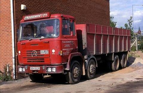
Top right of this image shows T&S Elements boatyard and head office in Salford Bridge mid 1950’s
Boats were purchased to complement the fleet throughout the company’s history, the maximum number believed to be nearly 200 craft at it’s peak just after the end of the second world war.
Representation of a cabin decoration for Shropshire, Worcestershire and Staffordshire Electric Power Company as used on ‘Stour Lifters’ or their fore runners.
One of the major contracts were to Stourport power station and lasted until approx 1948 for that reason I have included the fleet of the Stourport Light as the station was known in my list.
One of their longest contracts was the supply of boiler coal to GEC Witton from originally Hednesford collieries and latterly from Anglesey Basin. My family were employed on this contract for many years working with both horse boats and latterly using a motor and butties.
Foster family passing the under construction Dudleys Fields estate in Bloxwich in 1958
Charlie Foster on the motor Princess Anne in the distance with Horace and Billy Foster on the day boats behind.
By the early 1970’s the company’s fleet had reduced to about 6 boats, which were employed solely on factory rubbish contracts. What did they carry during their history? – Road stone, Coal, Coke, Coal slack, concrete Aggregates, Sand, Gravel, Tubes, Manure, Ashes, Blast furnace slag, Phosphorus waste liquor and Rubbish (no doubt there were many more!).
The firm continued once they gave up canal carrying and their fleet of lorries were a regular sight around the streets of the area.
Thanks to David Element (great grandson of one of the co-founders of T & S Element Ltd.) for his invaluable assistance with this account. David is researching the history of the company, and would be interested in hearing from anyone who has related memories or photographs, or who knows the whereabouts of any T & S Element boats still afloat or abandoned. David can be contacted by e-mail at: – david.element.1984@pem.cam.ac.uk
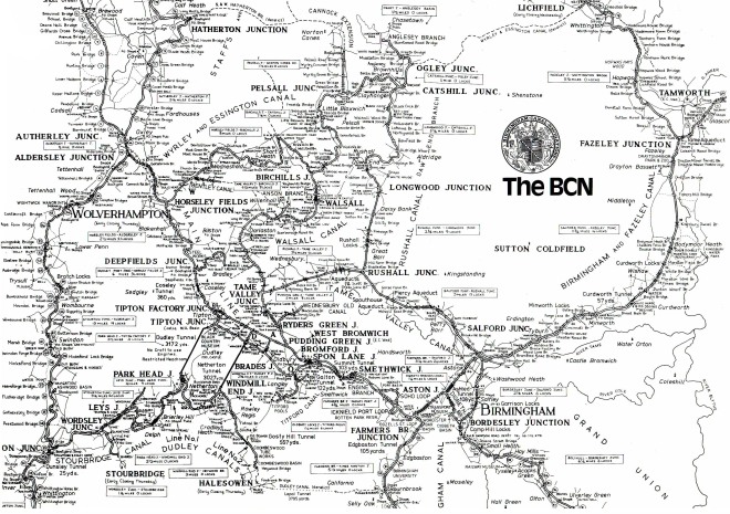
The Wyrley and Essington Canal is a canal in the West Midlands of the UK. As built it ran from Wolverhampton to Huddlesford near Lichfield, with a number of branches: some parts are currently derelict. Pending planned restoration to Huddlesford, the navigable mainline now terminates at Ogley Junction near Brownhills.
A Map of the whole Birmingham Canal Navigations system, showing how the Wyrley and Essington was just a part of it.
The canal was built to allow transport of coal from mines near Wyrley and Essington to Wolverhampton and Walsall, but also carried limestone and other goods. An Act of Parliament received the Royal Assent on 30 April 1792, entitled “An Act for making and maintaining a navigable Canal from, or from near, Wyrley Bank, in the county of Stafford, to communicate with the Birmingham and Birmingham and Fazeley Canal, at or near the town of Wolverhampton, in the said county; and also certain collateral Cuts therein described from the said intended Canal”.
As the act’s name suggests, this authorised the construction of the canal from the mainline of the Birmingham Canal Navigations (which would not be known as such until 1794) near Wolverhampton to Wyrley Bank, and the raising of up to £45,000 to pay for construction. William Pitt was appointed engineer.
A second act received Royal Assent on 28 March 1794, entitled “An Act for extending the Wyrley and Essington Canal” – this authorised a long extension, from Sneyd (thus making the line from Sneyd to Wyrley Bank effectively a branch) past Lichfield to Huddlesford on the Coventry Canal, together with the raising of up to £115,000 to complete construction. The section of this extension from Ogley Junction to Huddlesford is now known as the Lichfield Canal and is derelict but under restoration.
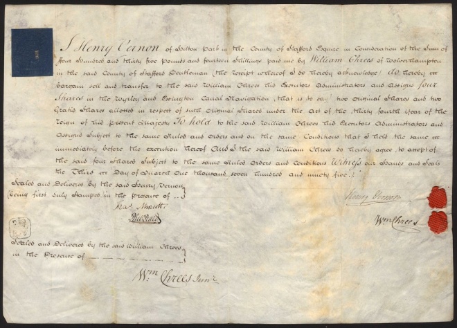
Wyrley and Essington Canal Co., a handwritten transfer certificate for 4 shares, 1795, between Henry Vernon and William Chrees , large format, on vellum, wax seals and handsigned by all parties.
The canal, including the extension, was open throughout by 1797.
In common with other canals in the Midlands, it was built as a “narrow” canal, able to take narrow boats approximately 70 feet by 7 feet (21.3 metres by 2.1 metres). Unlike many parts of the canal system the long lock free level, along with the numerous suppliers and customers within hailing distance of the canal, allowed larger boats known as Wharf boats or colloquially ‘Ampton boats (due to the fact the canal was on the Wolverhampton level, 473ft above sea level) up to 88ft long and approx 8ft wide to travel on them. These were able to carry up to 50tons on the same draft as a regular sized boat carrying 25-30tons.
The canal was lock-free from the Birmingham Canal mainline at Horseley Fields for 16.5 miles (26.5 kilometres), after which there were 30 locks descending to Huddlesford over a further 7 miles (11.3 kilometres). Branches
A number of branches were constructed:
*the section of the original mainline from Sneyd to Wyrley Bank, later considered a branch, was opened in 1798, some 2.2 miles (3.6 kilometres) long with five locks: this was later (1857) extended to serve more mines, eventually being 3.5 miles (5.6 kilometres) long. This branch was abandoned in 1954 but traffic had ceased by the mid 1930’s.
*the Birchills Branch was opened in 1798, 2.1 miles (3.4 kilometres) long, originally to serve the foundries based in the Birchills area.
*Essington Branch was a branch off the Sneyd to Wyrley Bank line and was opened in 1800, 0.7 miles (1.1 kilometres) long with four locks. The Essington Branch was the highest point on the system and its water came from pumping out the mines, so when the collieries were worked-out the branch lost both its trade and its water supply and was closed in about 1830.
*the Daw End Branch from Catshill Junction to limestone quarries and limeworks at Hay Head was also opened in 1800, some 5.4 miles (8.7 kilometres) with no locks
*Lords Hayes Branch was 0.9 miles (1.5 kilometres) with no locks: this branch has been abandoned but has been proposed to use the beginning of this branch as part of the new line of the Hatherton branch of the Staffs and Worcs canal.
*the Anglesey Branch from Ogley Junction: built as a feeder in 1800 to carry the main source of water for the canal from Chasewater Reservoir.
*the Gilpins arm, Slough arm, a private canal, about a mile in length, branching off the Wyrley and Essington Canal just north of Pelsall Common and the Cannock Extension Canal. Description of the Slough Arm taken from Richard Chester-Browne’s “The Other 60 Miles” : The canal was built to serve coal mining interests, and extended on three occasions as the coal seam was worked out and activities moved north. Unusually, this private canal included a lock the remains of which can still be explored. It is set in deep woodlands, in marked contrast to the coal mines which once surrounded it as it stretches up from the main Wyrley and Essington Canal to Brownhills Common, site of the Brownhills coal measures.” and the Sandhills arm which left the canal nr to Millfields School in Brownhills and followed the contour all the way to the farm where wharf buildings were recorded in the 80’s, all three arms are now abandoned
Merger
In 1840 the Wyrley & Essington merged with the Birmingham Canal Navigations (BCN) and several new connections between them were planned and built. The ½ mile Walsall Junction Canal with 8 locks from Birchills to the Walsall Canal opened in 1841; the 3½ mile Bentley Canal with 10 locks from Wednesfield to the Anson Branch of the Walsall Canal opened in 1843; and the Rushall Canal from the Daw End Branch to the new Tame Valley Canal with 9 locks in 3 miles opened in 1847.
In 1850 the 1½ miles long water feeder from Cannock Chase Reservoir to the top lock at Ogley was made navigable as the Anglesey Branch to serve the Marquis of Anglesey’s collieries, coal continued to be transported along the branch from Anglesey Basin until 1967. The end of this branch is the furthest north it is currently possible to travel on the Birmingham Canal Navigations.
The Wyrley Branch was extended 1½ miles to Wyrley Bank in 1857. It served a number of collieries and mineral mines but by the early 20th century trade was all but non existent on the branch and it fell out of use by the 1930’s.
The Cannock Extension Canal was opened in 1863 from Pelsall to Hednesford, 6 miles on the level, although the Churchbridge flight of 13 locks linking it with the Hatherton Branch of the Staffordshire & Worcestershire Canal and jointly funded by both companies had apparently been completed in 1860.
Traffic on these canals was intense, including coal, limestone, iron, clay, bricks, tiles and manufactured goods. The BCN remained busy well into the railway age when other canals succumbed to the competition, developing rail interchange wharfs for local collection and deliveries. Coal traffic off the Cannock Extension Canal to several power stations continued until increasing problems maintaining the level due to subsidence from coal mining resulted in its closure north of the A5 road in 1963. But by then, a 1954 Act had authorised the abandonment of Ogley Locks, the Wyrley Branch and Lords Hayes Branch.
Welcome to my new blog, I'm Andy, new to cycling, on wheels if not emotionally. Expect the unexpected, lots of photos and musings about history, life and everything in between.

")